Commentary
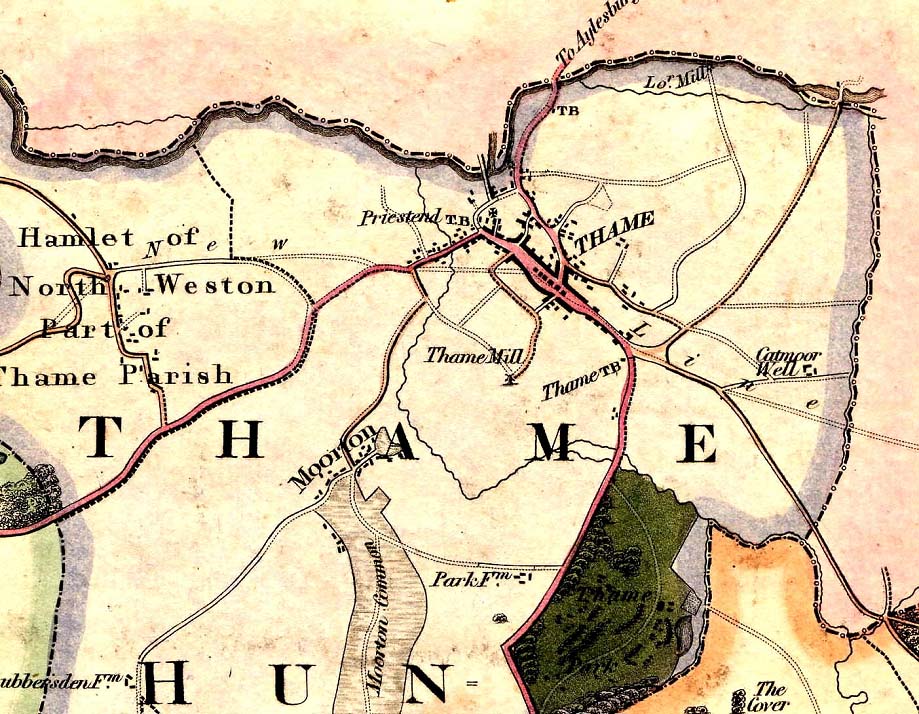
This map showing Thame is taken from a map of Oxfordshire made by Bryant in 1823.
Note the three places where the letters 'TB' appear. Toll Booths charged travellers for access to the main roads. The 'Priestend T.B.' raised a toll for travelling along what is now the A329 through Little Milton towards Stadhampton and on to Shillingford.
This was part of the Aylesbury to Shillingford Turnpike route, opened in 1770. Shillingford is of course across the River Thames from Wallingford and this turnpike provided a major trade route from the Midlands via Aylesbury to the Thames at Wallingford and therefore London.
There was another toll gate on the Aylesbury road itself.
The third turnpike is labelled 'Thame TB' and sat outside the old Police Station opposite the Falcon pub. Note however that in 1823 neither the old Police Station nor the Falcon had been built and there were no houses in Chinnor Road.
This maps seems to show the whole area around the bottom of what is now Queens Road to the start of Thame Park Road as an open area, with Queens Road fanning out at the bottom.
This toll gate controlled access to Thame Park Road, leading down to Postcombe, and was known as the Thame to Postcombe turnpike. At Postcombe (where the old toll house is today a prominent feature) this road joined up with the London to Oxford turnpike, which is now more or less the A40.
Note the word 'New' that appears above North Weston, and the word 'Line' that appears along Chinnor Road. These words are joined by two dotted parallel lines, indicating the course of a 'new line' of something.
The full map shows that this is the proposed line of a new road. It was to run from Princes Risborough to Towersey and into Thame, where it was to run along Chinnor Road and along the south side of the Upper High Street, and through the Cornmarket.
At a spot roughly where the Co-op is today, this new road was to turn and by-pass Priestend (cutting through the ancient burgage plots at an angle) and head off towards North Weston and Oxford.
There would have been a need to demolish a property on the south side of Thame's Lower High Street to accommodate the course of the new road, and its seems probable that this would have been the Knollys mansion that stood on the site of the Co-op today and was indeed demolished in the twentieth century.
This new road was never built. It would have provided good and relatively fast access to Thame and Oxford from High Wycombe and London, since the route from Princes Risborough to High Wycombe goes through what is known as the 'Wycombe Gap', a natural pass through the Chilterns which avoided the steep inclines of Stokenchurch Hill (which the London to Oxford turnpike had to tackle).
It would also have opened up a new route into Oxford through North Weston and Albury, where there had up to then been only trackways for farm workers and livestock.
Needless to say, it would have changed the face of Thame and the town's wide medieval high street would have gone the way of the many hundreds of others elsewhere in England.
What did happen, around ten years after this map was drawn, was the construction of a new turnpike road between Thame and Princes Risborough, providing access through the Wycombe Gap from High Wycombe, but taking a different line.
This new road simply headed off in a very straight line from Thame to Kingsey, and from Kingsey proceeded to by-pass Ilmer and drop down into Longwick. Around 1833 this 'New Road' cut through an ancient town enclosure called Whitehound Close at an angle and joined the end of the Upper High Street, being what is today East Street.
The other side of Thame, we can see that the A418 through North Weston and Albury came into being, so that the general objective of the 1823 proposed new road was eventually achieved, except for the fact that Priestend had not been by-passed. This did not happen until the late twentieth century.
The twentieth century builders of the M40, of course, did not need to look for a natural pass through the Chilterns. They blasted their own pass through them.