Today, it is part of Thame. Many people remember the old Luddesden Farm off Wellington Street, demolished around 1980 to make way for a housing development, comprising Wentworth Road, Fairfax Close and the roads behind.
There is also Ludsden Grove just to the west, an older housing development which took the place of a number of buildings, such as a saw mill, which perhaps lie beyond the reach of living memory.
The following extract from a 1767 map of Thame shows Ludsden before these modern housing developments :
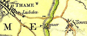
Part of the 1767 Jeffreys map
This picture in fact gives a strong clue to the origins of Ludsden. The name Ludsden, or Luddesden as it is sometimes spelt, is Anglo Saxon in origin.
The 'den' part of the name is likely to denote a clearing in woodland, and Ludd may have been the local chieftain. So how does an Anglo Saxon community dating to around the eighth or ninth century, judging by its name, fit into the picture as regards Thame?
As can be seen from the picture, Ludsden lies on the road from the heart of Thame to Towersey. If we extend this road in both directions, to Bicester via Long Crendon, say, and to Princes Risborough via Towersey/Kingsey, Aston Sandford and Longwick, then what we get is a possible salt route.
There were ancient salt pits at Princes Risborough and Iron Age salt containers have been found at Bicester. There is a possibility that Ludsden was a staging post on this salt route, and that it was in effect a commercial settlement set away from the heart of Thame, with its religious minster enclosure.
The building of New Thame in the twelfth century made Ludsden look out of place, as it then sat right up against the new town. It retained its enclosures and its separate identity however, as this extract from the 1797 Davis map shows
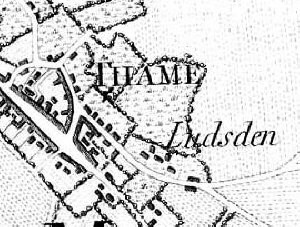
Part of the 1797 Davis map
The 1823 Enclosure Award for Thame effectively ended Ludsden's separate identity, and with the end of the saw mill and the farm it slipped away into history.
Old maps of Thame and the villages