Thame Local History
Old Maps of Thame

The map images displayed here are reproduced with the kind permission of Mr John Leighfield.

A commentary has been added by the Thame Historical Society Research Group, below each map.

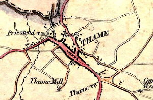
Extract from an 1823 map of Thame

Please note that the original maps cover Oxfordshire, and only that part of them around Thame is shown here.

The maps may take a few minutes to download.


  • Saxton, 1574
  • Saxton, Hole, 1610
  • Speed, 1611
  • Plot, 1676
  • Morden, 1695
  • Overton, 1715
  • Cole, 1715
  • Kitchen, 1760
  • Jeffreys, 1767
  • Davis, 1797
  • Cary, 1805
  • Greenwood, 1820
  • Bryant, 1823


  •             Home   |   Contents   |   This Site   |   Contacts   |   Email
      Local History Research Group
      Thame, Oxfordshire, England
      Information@ThameHistory.net